Ridea™: All 58 Counties

vaara

Well-known member
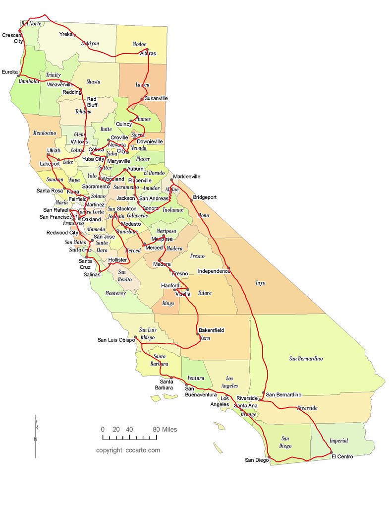
I'm contemplating taking my brand-new Wee out for a little spin, and by "little spin" I mean visiting all 58 counties in this great state of ours. I did that on my previous Wee, but over a period of several years. This time I want to do it all at once. I figure it would take 10 days - 2 weeks to do it right, i.e. not just crossing lines, but actually going to each county seat and taking pictures and shit.

I assume it's been done before, but a brief search found nothing. Anyone else intrigued? The first step is to figure out the route, then the timing. The vague plan is to hit the Bay Area counties, then meander northwards back & forth across the Coast Range and Trinity Alps. Then to the northeast, the Mother Lode, down 395 to SoCal, and finally back up criss-crossing between the Valley and the coast. I estimate the total mileage would be on the order of 3000, give or take a few hundred, but who knows?

Anyone know a map nerd who could help figure out the most efficient route? :nerd

Is anyone else interested in this insanity, or am I like, literally, the only one?
 

motomania2007

TC/MSF/CMSP/ Instructor
Sounds like a fun trip.

Many years ago, I read about someone that had visited all counties in the entire country... They worked on it for many years.
 

budman

General Menace
Staff member
Not a map nerd, but looking forward to see what you come up with.

Not sure how many I have ridden in, but there are certainly a few down south I have not done.
 
alway sort of thought it would be cool to visit each county seat in CA ... they are all supposed to have a courthouse ...

California superior courts

Historic California Courthouses

california-county-seats-map.png


courthouse would be something to take a pic of in each county, to document the ride, anyway ... :laughing

town name for each county would be a google-maps-directions start, too ... :gsxrgrl

isn't "the most efficient route" problem some crazy-hard computer science algorithm issue ...? :dunno

Shortest path problem
 
Last edited:

jmillington

Browser, Purchaser
This is a classic computer science routing problem (aka Traveling Salesman Problem) that is a surprisingly difficult problem to solve for the shortest overall route.

With 58 counties in CA, the brute force method requires that you consider 58! (58 factorial, i.e. 58*57*56*etc.) which is 235,056,133,128 possible routes!!

It would seem that just always going to the next closest county would be the answer, but that is generally not the quickest route.

There are algorithms that cut the amount of brute horsepower required to solve this problem, but this problem makes my head hurt! :afm199

:thumbup

fun to think about ... maybe ditch the county seats idea, and try hwy routes and see how many counties you get?:

San Francisco to 280 to 101 to 880 and over to San Rafael and Hwy 1 to Hwy 299 to Hwy 96 to I-5 south to Hwy 152 to 101 south to I-5 to I-8 to El Centro, Indio, Barstow, Hwy 58, Hwy 99 north to Hwy 36 to Hwy 89 to Hwy 299 to Hwy 139 to Hwy 395 south to I-80 west to Hwy 89 south to Hwy 395 south ...?

:loco

looks like that misses at least Del Norte County ... prolly hits a bunch twice, too ... :dunno

:ride
 
Last edited:

vaara

Well-known member
Heh. Yep. I’m already trying to figure out how to get from Crescent City to Yreka without going through Oregon or backtracking all the way through Eureka or taking fire roads, which aren’t my thang.

OH WAIT! My ride, my rules! Cave Jct here I come!
 
Heh. Yep. I’m already trying to figure out how to get from Crescent City to Yreka without going through Oregon or backtracking all the way through Eureka or taking fire roads, which aren’t my thang.

OH WAIT! My ride, my rules! Cave Jct here I come!

:thumbup

looks like you could also maybe do an out-and-back from Happy Camp/Hwy 96 onto Greyback Road and clip Del Norte County just before the state line ... :ride

if I google a CA county for it's wiki page it looks like I can click on the map on the wiki page and get the county outline on google maps ... link is showing the county line on my work computer ... :party
 
Last edited:

vaara

Well-known member
I’m old school, mate.

CA-C1-e1508257772589.jpg


Pro tip: This paper thing shows which roads are paved and which are un-. Which is handy.
 

berth

Well-known member
This is a classic computer science routing problem (aka Traveling Salesman Problem) that is a surprisingly difficult problem to solve for the shortest overall route.

For the absolute shortest route, yea it can be pretty tough.

But for a "pretty short" route, its far less of a problem.

I'm only sorta surprised Google Maps doesn't offer a nascent service for this.

Use main freeways and highways to do the bulk of the connections (vs the myriad of goat paths and such that are actually available) to rough it out.

I have code at home somewhere that worked this problem.

We're I motivated, I'd take the county seat names, and feed them all into google to get its "distance between seats" for each pair. That would be the raw dataset. It's 3364 data points total (58*58), rather than 58!.

Once you got an order, feed that in to maps for actual routes. Google can route destinations in order, but not "take me to all these places".

At least I don't think it can.
 

dravnx

Well-known member
There's lots of software out there that will do it for you. Google "vehicle routing software". Many of them have free trial periods so you can play with them.
 

vaara

Well-known member
Here's a very, very, very preliminary attempt at a route. There's a bit of doubling-back, but it doesn't cross itself, so there's that.

Oh, and I literally just drew on it with the pencil tool in Paint, so it doesn't actually reflect how the roads run, except for Hwy 4 of course. :)

49565970366_25ce149b39_b.jpg
 
Last edited:

Alan_Hepburn

Well-known member
Our GWRRA California District has this planned for this year as a state-wide rally:

12-13 September - Merced - 13 Counties
19-20 September - Yuba City - 10 Counties
24-27 September - Redding hosted by CA-2R - 7 counties
3-4 October - Victorville hosted by CA-1V - 6 counties
10-11 October - Sacramento hosted by CAC - 15 counties
17-18 October - Bakersfield possibly hosted by CA-1L and CA-1A - 7 counties

We even accept non-Gold Wing riders!
 

vaara

Well-known member
Very cool! I'm based in SF though, so the travel time to/from the start/end points would make those unfeasible, esp. for someone who's not on a Gold Wing and has to stop about once an hour to stretch. :)

My idea is to do it all in one fell swoop. Or two at the most.
 

Heywood

Well-known member
Yikes, that stretch of 395 slab out of San Berdoo to Independence would be tough to swallow. I like the desert but sections of that are :green. Gotta time that one right too so you're not dying of heat or freezing.
 

vaara

Well-known member
Yikes, that stretch of 395 slab out of San Berdoo to Independence would be tough to swallow. I like the desert but sections of that are :green. Gotta time that one right too so you're not dying of heat or freezing.

Yep. I hate, hate, hate that road, esp the 2-lane section south of Inyokern. I suppose I could hop onto 14 instead, but that wouldn't be much of an improvement.

And yeah: weather. Besides the heat/cold, the wind is a big problem through there.
 
ha, lol'd with delight ... you win the motorcycle BB today! :thumbup

Here's a very, very, very preliminary attempt at a route. There's a bit of doubling-back, but it doesn't cross itself, so there's that.

Oh, and I literally just drew on it with the pencil tool in Paint, so it doesn't actually reflect how the roads run, except for Hwy 4 of course. :)

49565970366_25ce149b39_b.jpg
 
Top