Solo on the Carrizo

ScorpioVI

كافر ლ(ಠ&
Skip to Post #2 if you're just here for the Carrizo...

As in Carrizo Plain National Monument. I had intended to check out the roads down south earlier this year, but weather and work conspired to get in my way. Enter the BARF Spring Rally on the Central Coast. Hmm, three days with a bunch of other BARFers riding around Paso Robles... IN! That was February, I made my reservations and forgot about it until flying_hun sent me the participant package on the last week of May. Whoops, is that next week? Then came the rush to get the bike ready to roll, but come go time I was ready.

Friday morning had me up and early lubing and adjusting my chain before meeting at Snellbucks for the rally start. Made it there, signed in, turned on my SPOT tracking, so far so good. First stop of the rally was Laguna Seca, via Uvas/152/Elkhorn Slough Rd. just like any other riding weekend.

About as close as the KLR will ever get to riding on the track...

558399679_yv3aF-L.jpg


They were running some kind of 24-hour race while we were there.

558287836_czHTB-L.jpg


The kind folks at Laguna were generous enough to give away a package for the 2009 MotoGP consisting of 3-day tickets, paddock passes, preferred parking, etc. As is usually my luck with raffles and such, I got jack_. I take that back, I did score an awesome purple bandanna. :laughing

Back on the road, Laureles Grade to Carmel Valley Rd to Highway 1 were awesome. Haven't done those roads before but it felt a lot like sections of 198. Loved it. Blew through Carmel and onto Big Sur, passing 4-wheelers and getting passed by other rally participants on much faster sport and sport-touring bikes. I was in bike heaven, the Highway 1 section at Big Sur is magical to me. Every time I ride it I enter into this zen state of mind. I am here, I am alive, this is as good as it gets. I did not stop or get off the bike for the next 106 miles. Which means no pictures, but in my defense, no pictures of Big Sur will do it justice. You'll just have to get there and ride it and see for yourself.

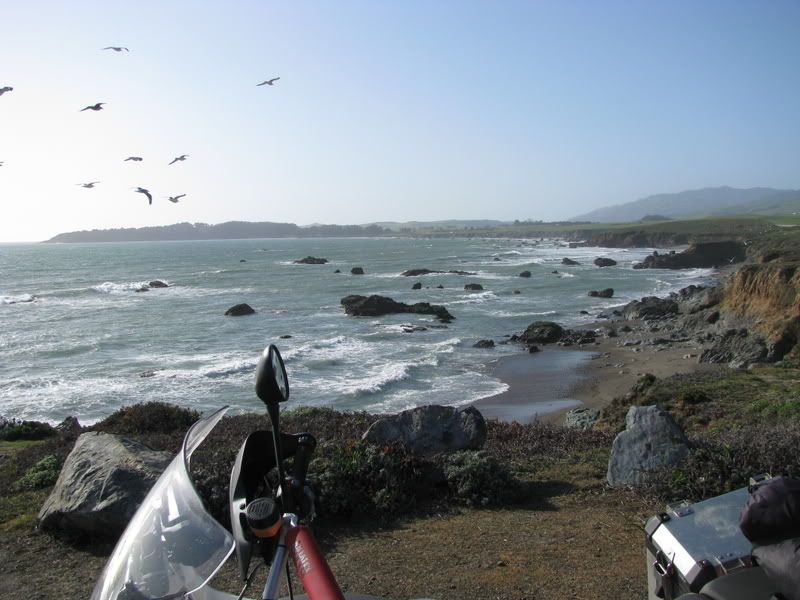
Nature did come calling, nay, screaming at me just past San Simeon/Hearst Castle and I finally ended up pulling out onto a vista point.

558288097_uxvJn-L.jpg


558286587_euENL-L.jpg


See, pictures just doesn't do it. So as I was putting my camera away I noticed this feller kept inching closer and closer to me...

558286560_ya89c-L.jpg


He looked skinny and pitiful, with his coat all tattered. So I fed him some crust off my Starbucks Turkey Club sandwich while I told him stories and about how long I stayed on that KLR... "NO WAI!"

558287874_tWQFd-L.jpg


It was an ambush! It turns out they put their skinniest squad member out on point, so you take pity on him and bust out the food. As soon as you do, the rest of the fat bastards jump on you and rip the sandwich off your hands and go to town! I was outnumbered... and like a squad of Squirrel Spetsnaz, they quickly surrounded my egress point, these bastards were good!

558288015_s69Hu-L.jpg


I was a soldier, trained in immediate ambush and counter ambush tactics, and I am an eskrimador, I'd rather die than flee from squirrels! I whip out the Emerson and charge...

558287933_hNgxY-L.jpg


... and that little bastard sneezes at it and goes right for my hand! Disarmed! Pride and dignity be damned, I got out of there like the boyfriend running from the husband. But not before flashing him the bird! Laugh! But I did feel better...

558287906_BGFRz-L.jpg


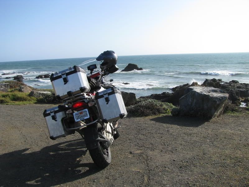
Mortifer was smart enough not to stop at the Squirrel Ambush Point.

558288122_nPLUC-L.jpg


I hastily mounted my steed and got out of there. A little further south on 1, then my Zumo pointed me towards Santa Rosa Creek Road. Or I thought it did. It took me on this roundabout way to get there, with some unfortunate BARFer on a GS following my hasty corrections. Anyways, we ended up on Santa Rosa Creek Road where the BARFer on the GS proceeded to show me how a goat trail oughta be tackled, my pride took a hit, but I was grateful for the company. We ran into flying_hun and a few others up the road and our group ended up taking 46 to Vineyard, where I promptly got left in the dust and my Zumo pointed me to another road than what the group was taking. Oh well, I actually ended up at the hotel a few minutes earlier. :laughing

Which one of these things just isn't the same... Here's Budman "The New BMW Owner" sneering at my KLR. "Oh, so that's what one of my BMW monthly payments look like."

240.jpg


I showered, grabbed a couple of tacos and an enchilada and a real Mexican coke from the Mexican place next door, ate, and took a nap.
 
Last edited:

ScorpioVI

كافر ლ(ಠ&
So I had briefly heard of the Carrizo Plain on ADVrider.com forum. Didn't really give it much thought then. Sometime after my Mexican-Coke-induced nap, I started thinking about what roads to do for the day after. I had done some research on the roads around the Central Coast earlier this year when I was planning a trip, but nothing really stuck in my head. I had my AAA "Coast and Valley" map open and was just sort of tracing lines around the map when I saw the bright orange shade of the Carrizo Plain National Monument. Bingo! I briefly recalled some dirt roads there, so to dirt we go. I had briefly entertained the idea of trying to talk people into going with me, but then looking at the bikes in the Motel 6 parking lot... nah. I was gonna have to do it solo.

This is the loop I decided on. I thought about taking 33 down to Ventura, but really didn't want to fight the traffic to get back into Paso Robles. And I had a dinner deadline.

558397227_cSBrV-L.jpg


So after grabbing a couple more hours of sleep, I was on the road by 10AM, great, plenty of time I thought and a brief look at the Weather Channel indicated that the weather was clear for the area! Filled up at the 76 on Golden Hill Rd, grabbed a snack and a couple of water bottles and I was on my way. South on Golden Creek towards Creston Rd (where Machete passed me then disappeared), then South-East on La Panza Rd to Hwy 58. Things didn't get fun until La Panza, which reminds me of Highway 25. Gently rolling hills with some nice sweepers cutting through mostly farmland and wineries. Hwy 58 was better, lots of altitude changes as it climbs up the mountains before dropping down into the plains.

One of my few shots of Highway 58...

558286616_q997E-L.jpg


This is after the mountainous section nearing Soda Lake Rd. Not a very exciting section, straight lines for miles, then two 15mph right angles, then more straight lines.

558286673_AVmyp-L.jpg


But then I saw the sign pointing towards Soda Lake Rd, and the Carrizo Plain National Monument, sweet! A few more miles brought me to this...

558292154_gkHJ5-L.jpg


But then nothing else. The only sign that there was civilization was the the remnants of a mining operation that you can see just off to the left of that picture. I could see bits and pieces of Soda Lake, but couldn't really get any good shots of it. Then I came up on a bit of dirt road that led up to the Soda Lake Overlook, but it was a long walk up the hill and I didn't feel up to it in my gear so I just grabbed a map of the plains and went on my way.

This is the paved section of Soda Lake Road, Soda Lake is off to the left somewhere.

558286779_tqt67-L.jpg


A little shot of my big head with the lake behind it.

558286796_Dh6g8-L.jpg


A couple more miles down the road and I finally see a building off to the right. It's the Goodwin Education Center, where I ran into the park ranger and ended up picking his brain about the roads I was planning on doing. "You by yourself?" "Yup." "Oh." He seemed concerned... I was beginning to be... I asked him about the condition of the roads, he pointed to that little 100-yard stretch that goes off Soda Lake Rd towards the Education Center, "'bout like that". No sweat, I thought.

Here's my tracklog of Carrizo Plain so you get an idea of the scale. The blue section is all dirt and tallied to 56.4 miles, minus a couple for a little backtracking.

558510730_mzFdH-L.jpg


About 5-6 miles from the Education Center, I come to this!

558286872_XL6Yu-L.jpg


You're probably wondering to yourselves, it's only dirt, what's the big deal? Well, prior to me getting the KLR earlier this year, I had mostly spent the last 7 years of my riding career on sportbikes. Dirt was something that I avoided at all cost. And the only dirt experience I had was when I went off on Turn 5 and took a shortcut to Turn 6 in Thunderhill. And there was that one time on Del Puerto Canyon Road when I target-fixated on a right-hand sweeper, crossed the DY, and dumped the bike on the dirt turnout just shy of a 50-foot drop-off. So yea, me and dirt, we got history, and it ain't a good one. So when I got the KLR and began exploring dirt roads, I did it with trepidation. Up until this trip, I had maybe 100 miles of dirt experience, total. Dirt, quite frankly, scares me, and so the way I deal with it is by riding more of it...

And so it begins.

558286929_ZxNbh-L.jpg


I think I lucked into the perfect riding weather to do the Carrizo by the way. It was probably 70, at most, some sun but mostly high cloud cover. It kept the day cool. I can't imagine doing this trip in the middle of August, it must easily get to the high 100s in this valley.

Nevertheless, with the roads marked as "Rough Road, Impassable When Wet". I kept a close eye on the sky!

558286905_9qBY9-L.jpg


What's the big deal you ask, well if there's anything I fear more than dirt, it's mud. I somehow have a talent of making the bike go in a straight line... while cocked 90º sideways... sliding towards inevitable shame. So I hate mud, and the only way I deal with mud... is by not riding it! It's not that I'm a pussy... it's just that I'm a pussy on mud.

And the road keeps going on... with views like this...

558292177_QusQP-L.jpg


... and this...

558286948_VGZqG-L.jpg


OK, so it's not exactly the Sierras, or Big Sur. But it's beautiful anyway. Something about the desolation and isolation draws me. I'm only about 10 miles in at this point, but I hadn't seen a soul since the park ranger. And as it turned out, I wouldn't see another human being for the next 50 miles.

558286972_GiGXd-L.jpg
 
Last edited:

ScorpioVI

كافر ლ(ಠ&
Something I didn't realize about Carrizo Plain, until I downloaded the GPS data, was how high up it was. I could've sworn it was at sea level, but I was actually already 2000 feet up. GPS no lie...

558397257_bsjHJ-L.jpg


And then it was more of this...

558286929_ZxNbh-L.jpg


This dirt portion of the Soda Lake Road was in pretty good condition. It was mostly hardpacked, and the only danger really came from the loose dirt on hardpack on some of the turns that made my Kenda K270s slip around a little. I was averaging about 40mph on the stretches, you could probably go a lot faster, but I thought it best not to tempt my luck being this far from help.

558287035_6ysyY-L.jpg


Aside from the abandoned and decrepit buildings of the Traver Ranch (locked behind a fence and now occupied by the local bats) this was the only other sign of a domicile in the area...

558287018_oHfXb-L.jpg


There were signs of cattle-ranching operations, a couple of barns and some corrals, but I didn't see anybody working them, or any cattle for that matter. Even wildlife was pretty sparse, with the exception of birds, I only saw a couple of field mice on this run. I saw a lot of dirt roads branching off in all kinds of directions, but didn't want to take any chances exploring them. If I went down and was injured somewhere off the main roads and couldn't get to my SPOT, the chances of anybody finding me in time to matter was pretty remote.

22.5 miles of dirt later I ended up on what should've been the junction of Soda Lake Rd. and Elkhorn Rd. Only there were no signs. Just the usual "Rough Road, Impassable When Wet" signage. Hmm. Taking my chances I went up the one dirt road that goes up and over a hill, only to find that it split off into three on the other side. Damn. Noting some recent tire tracks, I took the middle fork and ended up here...

558287106_JWYtD-L.jpg


... where the road forked again. Doh! Deciding it was too treacherous to try and turn around on the steep slope, I decided to keep going and found out the fork actually loops on itself. Oh well, time for lunch...

558287134_vPPpj-L.jpg


Aquafina and Ritz Bits, great survival food! I really should've prepared a little more for this jaunt. It was nice up there though, with a good breeze blowing, I took a few minutes to lay on my back and just stare up at the sky. I did notice a little bit of civilization past them hills... (probably Taft or Maricopa)

558292198_dMkrA-L.jpg
 
Last edited:

ScorpioVI

كافر ლ(ಠ&
After the break I decided that I was on the wrong track, and, decided to backtrack down to Soda Lake Rd and see if I can find the real Elkhorn Junction. You can see in the track I posted that I actually started heading south towards 33, but when I saw 33 coming closer and closer on my GPS, and no sign of Elkhorn Rd. I decided to turn back and go up to where I was. These bastards are really going to make me go up them hills? Sigh.

So back up the steep road I go, this time I turn left at the 3-way fork. Aha! Looks like I'm on the right track. I'm cresting over a hill and into what looks like another valley. I should note that the "CA Topo" I downloaded for my Zumo was worthless here, since there was no map data whatsoever.

558287182_XTgHE-L.jpg


A couple of miles on I thought I could make out the faint outline of what I hoped was Elkhorn Rd.

558287271_scKyU-L.jpg


This track ended up winding down a set of hills via a series of switchbacks, would've been fun if I was going up. But going down I was paranoid about blowing a turn and launching myself off the side of a hill. So I went slow. And then... that faint outline was becoming bolder...

558287298_P9aJw-L.jpg


And finally, aha! Elkhorn Rd.

558287474_iqBeT-L.jpg


Elkhorn Rd runs parallel to Soda Lake Rd. Only it's on the other side of the plains, across the San Andreas fault. It is also much much more remote, and judging from the road it looked like it was much less traveled. There was supposed to be another road that led off towards Maricopa, but again, I didn't see any signs and there were a lot of tracks criss-crossing the place. Could've been any one of them.

Elkhorn Rd however, seemed like it would just go on to the Horizon...

558287430_zXMUC-L.jpg


Out here it seemed like I was the only man left on earth. In fact, when the zombie apocalypse comes, I think I'll come here, somehow I think in the stupid zombie mind they would take one look at this place and go, "fuck that, ain't no food there." and go stumping off to Ventura or Bakersfield. Pictures just don't do it justice. I needed like a wide-angle lens to take in the expansiveness of this place.

558287495_osjyA-L.jpg


The road itself was far more interesting than Soda Lake. It wasn't as well-traveled, as a consequence it also wasn't as hardpacked. Lots of loose sand made my life a little more interesting than I generally like, along with a few elevation changes and some bumps that bottomed-out my suspension. I got lost in the sheer act of riding, miles didn't matter as much as the next 100 feet in front of my bike. I learned what these dirt-riders meant by "body steering" and "steer with your rear tire". I learned to relax and breath. And by the time I turned off Elkhorn to go up Hurricane, I felt damn good about my dirt-riding ability. But that was before Hurricane Rd...

558397257_bsjHJ-L.jpg


See that little sharp spike on that graph? It's called Hurricane Road and Temblor Ridge. I fucking trembled all right. What kind of sadistic bastards would cut a road that doesn't just climb over a ridge via switchbacks, but cut a road with a 1000-ft drop right next to it.

This, was the easy part, why? Because I took a picture, with my left hand. Right hand on the front brake, right foot on the rear brake, keeping the bike from sliding backwards.

558287536_GxdHu-L.jpg


After that I took this one of what looked to me was a long way down to a hopefully painless death. It's blurry, because my hands were probably shaking. I made the mistake of looking down and damn near puked. Ugh. I was at the Grand Canyon a couple of months ago and standing a few feet from the edge of that, and riding a few feet from the edge of this ridge were two completely different experiences. Did I mention I don't like heights?

558287563_3Ne9L-L.jpg


I know it doesn't look like much, and it probably wasn't. But I zipped up the camera and rode like 5mph for a while til I crested the top of the ridge. The other side wasn't nearly as bad...

558287590_CGGzd-L.jpg


A little further down...

558287628_M75XX-L.jpg


And finally I was almost out of it...

558287674_zU7Lw-L.jpg


The other side was a lot gentler slope than the climb. And eventually I hit pavement near the oil fields North-West of Taft. A quick lunch and gas at Taft and then it was 166 miles non-stop back to Paso Robles, via Maricopa, 33, 166, 101, 1, Old Creek Rd, 46, Vineyard, and Adelaida.

No pictures though, somehow after Carrizo Plain, posting a picture with civilization in it almost seemed obscene.

And that's my Carrizo Plain story. Might not be the most adventury, definitely not the gnarliest of trips, but I kept going where most others turned back, and I did it solo, and learned a lot about myself. Where I go from here, I don't know. Definitely Baja in November, maybe Tierra Del Fuego after that? Who knows. Wherever it is, I'll take it 100-feet at a time.
 
Last edited:

flying_hun

Adverse Selection
It took me on this roundabout way to get there, with some unfortunate BARFer on a GS following my hasty corrections. Anyways, we ended up on Santa Rosa Creek Road where the BARFer on the GS proceeded to show me how a goat trail oughta be tackled, my pride took a hit, but I was grateful for the company. We ran into flying_hun and a few others up the road and our group ended up taking 46 to Vineyard

:rofl:rofl:rofl Great story! :thumbup You gotta watch those little bastids! :mad

The BARFer on the Beemer is my buddy, Kluts, AKA Jim. It was great to have you join us on that little jaunt up Santa Rosa Creek. :thumbup Looking forward to your report on Carrizo.
 

luckett

The Green Bastard
I somehow have a talent of making the bike go in a straight line... while cocked 90º sideways...

You're a future dirt track champion, you just don't know it yet. :rofl Get a lightweight dirtbike and it will cure you of your fears.

You almost made it to some really good riding. Lots of good stuff in the los padres.
 

mlm

Contrarian
Great write up :thumbup

I remeber those squirrels from when my wife and I went to Hearst Castle. They were really freaking her out. :laughing
 
those pics are absolutely amazing!!!!!!!! Love the bright puffy clouds, scenery, roads disappearing into the distance.....Well done Al!:thumbup
 

kluts

The Lost Tour Guide
FAntastic report on the Carizzo plain. That GS rider was me as Kurt points out. Here is your pic on Santa Rosa Road just after we passed Clem, Wade and their dog in the pickup.
 

Attachments

  • IMG_1929.jpg
    IMG_1929.jpg
    95 KB · Views: 64
Last edited:

Cycle61

What the shit is this...
Dirt, quite frankly, scares me, and so the way I deal with it is by riding more of it...

Nevertheless, with the roads marked as "Rough Road, Impassable When Wet". I kept a close eye on the sky!

What's the big deal you ask, well if there's anything I fear more than dirt, it's mud. I somehow have a talent of making the bike go in a straight line... while cocked 90º sideways... sliding towards inevitable shame. So I hate mud, and the only way I deal with mud... is by not riding it! It's not that I'm a pussy... it's just that I'm a pussy on mud.

Heh. I'm with ya, except I kept going at "Impassable When Wet" :laughing
 

J-Boat

Read Only Lurker
FAntastic report on the Carizzo plain. That GS rider was me as Kurt points out. I will post your pic on Santa Rosa Road later this evening. Watch this post for an edit!

Nice write up man. That takes some cajones to go out alone on a road like that...

Here's a pic of your stop on Santa Rosa Creek. That was one of the goatiest roads I've ever ridden on!...

click for larger image
0 (33).jpg
 

racerXgirl

Well-known member
Wow! I shoulda gone with you! I've been needing to get some dirt time in on the DR. What tires are you using and how do you like them for the stuff you went through?
 

budman

General Menace
Staff member
Awesome write up Alan :applause

Pics, humor.. the :ride

Really glad you came down.. and I got to share your ride!

:smoking
 

longtallsally

Well-known member

Gee, that looks familiar...

350.jpg


352.jpg


Great write up! :thumbup I can't believe you made it to Carizzo before me. Although I did rock the the WR for 650 miles in under 36 hours to Pozo for some trails and a night under the stars a few weeks ago (Los Padres NF). Then I did part of the Sheet Iron the next weekend with it. Once I'm employed again, farkling shall commence as I've FINALLY been given authorization.

You should have told me you were going and there would have been another GS to abuse you. :laughing If you want, I'm heading to Tahoe this weekend for some proper trails on the pig with a bunch of other big bike guys, so it shouldn't be over your head...
 

ScorpioVI

كافر ლ(ಠ&
FAntastic report on the Carizzo plain. That GS rider was me as Kurt points out. Here is your pic on Santa Rosa Road just after we passed Clem, Wade and their dog in the pickup.


:laughing Those two kinda cracked me up, definitely some good 'ol boys there. Thanks for the pic!


Wow! I shoulda gone with you! I've been needing to get some dirt time in on the DR. What tires are you using and how do you like them for the stuff you went through?


I've got the Kenda K270s. They're wonderful on dirt, had no issues at all on the Carrizo, even through some of the deeper sand sections. They dig in and track nicely.

On pavement is a different issue, the knobs are pretty soft (you can wiggle it around with your fingers) and when you're at a lean you can feel them shifting around. It's a little unsettling at first. I've read the same complaints from others running the K270s.

These are only the 2nd set of tires I've had experience with on the KLR and they're a big improvement over the Kings KT-966 that were on there before. Those things were like rocks in comparison.
 
Last edited:
Top