Weaverville HoHo Outlaw Mendo Grand Tour, 2020

My fav BARF Rally every year is the two wheel tramp-organized Weaverville HoHo Magic Rally, but this year it had to be unofficial due to Covid-19 concerns.

So, some of us attended the "outlaw," unsanctioned version, scheduled for July 24th - 26th, 2020.

As is my wont, I left five days in advance, on Monday July 20th, so I could get to Weaverville a day early after a Grand Tour of the eastern side of the Mendocino National Forest. :party

ap.klr_.sunset.jpg


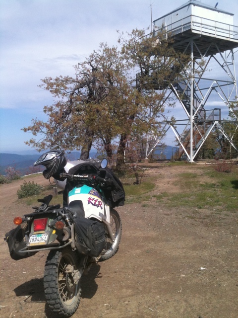
Here's a Relive link to my Monday route, Lower Haight to Anthony Peak. Anthony Peak is at around 7000 feet in elevation and is four or five hours from San Francisco. The Relive vid shows I-80 east to Pleasant Valley Road to Winters and Capay and Hwy 16, Bear Valley Road, Stonyford for gas, Elk Creek to left onto Rd 308 and up to Ivory Mill Saddle and M-3 to FH-7 to right onto M-4 and left onto Forest Rt 23N60 up to the watch tower.

When I got up to Anthony Peak, there was someone else there which is unusual, in my experience. Generally have the place to myself on a week night, as the USFS rangers work the tower on a strictly 9am to 5pm basis.

My new friend's name was Brian. “This is one of the darkest places in the USA and I’m here to photograph the comet” he told me. He had four camera rigs, three for the comet and one for the Milky Way.

brian.jpg


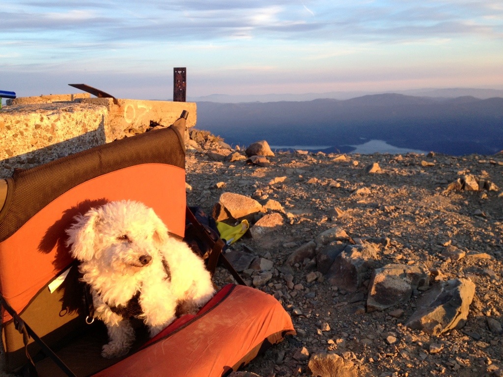
My campsite and tent all set up for the night, with Brian preparing one of his cameras for still shots ...

Brian taught me a lot about the incredible stars we were looking at, and promised to send me links to his time lapses of the comet and Milky Way. We also saw a bunch of shooting stars and satellites ... he was good to his word:


The twin peaks in the morning of the comet time-lapse are in the Yolla Bolly Wilderness. The time-lapse itself was over the course of the night.


The cars you can see on the right of the Milky Way time-lapse is traffic around Covelo.

We enjoyed a spectacular show from the comet and Milky Way. :gsxrgrl

Here is a link to Brian's photography website. It is worthwhile, imo, to click through to his Vimeo stuff, pretty awesome.

After waking up at 5:30am to view the sunrise, we said our goodbyes, and I was off toward Red Bluff for gasoline ...

blackbutte.jpg


My favorite view of Black Butte in the distance and the road to Weaverville, on the way down from Anthony Peak ... :ride
 
Last edited:
Here is a link to my Relive route on Tuesday from Anthony Peak to Knob Peak, just north of Hwy 36:
https://www.relive.cc/view/vQvxZgRNk96

The route shows M4 to M2 to M22 to Red Bluff for gas, to Reeds Creek Road up to Pettyjohn Road, FH 35 up to Rat Trap Gap down to Platina, left on Hwy 36 and right onto Cow Gulch and Knob Peak Lookout Road.

The crazy jog out to Red Bluff is made necessary by gasoline, but there is also no directly north route that I've found, due to the Yolla Bolly Wilderness and the huge Cottonwood Creek watershed that helps drain the wilderness area ...

noblade.jpg


a view along M22 ...

rattrapgap.jpg


Rat Trap Gap road signs on the way down to Hwy 36 ...

The watch tower on Knob Peak turned out to be behind a locked gate, but I was able to find a nice place to camp a few miles back down the in-and-out road:

nearknobpeak.jpg


knobpeak.camp_.3.jpg


actually got kind of lucky and wound up at a viewpoint where I could see the sunset, the comet and the sunrise ... :ride
 
Last edited:
Wednesday was my big hard day, to try to get my old self and my overloaded old KLR up to the Cal Fire watch tower on Bully Choop ... :party

Here’s a link to the Relive Bully Choop route:
https://www.relive.cc/view/vrqD4BxWnLq

basically Hwy 36 east to left on Platina Road (the cool old Platina Store had a sign: “Closed Forever” so no water there for me) to left on Bully Choop and follow my nose to the top, if able ...

klr.hairpin.jpg


some of the hairpin at the top, separated by a few short sections of ride-like-you-really-want-it, never my preferred mode of KLR riding ... :laughing

in any event, made it up, barely.

suprised to find it staffed by a nice 22 year-old fire-fighter, keeping an eye out for lightning strikes from the thunderstorms that quickly started bearing down from the south west toward the north east.

Chris said the three Cal Fire watchtowers in that area of CA are active during lightning storms from 8am to 8pm, in part because Cal Fire personnel are on duty 24 hrs/day for three days (and then off four days).

he emailed me this pic of the watch tower taken this past winter by a Cal Fire helicopter:

bullychoopwinter.jpg


he told me stories of what it has been like being employed by Cal Fire the past five years, and about the recent Carr Fire firestorm near Redding, and was kind enough to let me hang out with him for a few hours ...

bullychoop.sunset.jpg


at 8pm Chris was off down the mountain, leaving me to the sunset ...

klr.shasta.jpg


Mt Shasta made an appearance Thursday morning ...

shasta.road_.jpg


bullychoop.rocks_.jpg


some views on the way down toward Buckhorn Summit and Hwy 299 on E. County Line Rd ...
 
Last edited:

budman

General Menace
Staff member
Awesome beyond amazing. :thumbup

You live well my friend. Gloriously so...from my moto oriented life’s view.

Well done :applause

Fucking outlaw :twofinger :love :ride
 
Thanks for another great RR SFMCjohn!

Incredible Comet footage from Brian at Anthony Peak!

Looking forward to the rest.
 
So, the rally was awesome, as usual ... maybe 20 people at the outlaw version, as opposed to maybe 60 last year. We had a Rally Mistress two wheel tramp pizza party on Friday after everyone arrived, and Bobbert, the 49er Motel jefe, took good care of us the way the 49er Motel always does.

nystripsteak.jpg


dravnx cooked us N.Y. strip steak on Saturday night ... :party

jeffalex.jpg


dravnx and Mellowtonin ...

49erhangout.jpg


some of the gang enjoying the shade near the pool ...

john.coffee.jpg


my friend m0t0_ryder got up at 5am and rode up to the Weaver Bolly watch tower on Friday morning and enjoyed some coffee ... :ride

tomjohnaaron.bikes_.jpg


anytwowilldo, m0t0_ryder and lunch box, on the fire roads around Weaverville Saturday morning.

tomarronjohn.coffee.jpg


waiting for the sunrise on Weaver Bolly on Saturday morning with the Trinity Alps in the background .....

windsoraction.jpg


my friend wowens, demonstrating how steep the climb up to the watch tower can be ... :ride

wb.bikes_.sunrise.jpg


and, the sunrise on Saturday ...

weaverbolly.sunset.flowers.jpg


the wildflowers had enjoyed the thunder showers on Tuesday night ... sunset from Weaver Bolly ... think I made the twenty-mile round trip from the motel parking lot six times over the three night I was there. :laughing

17885c6c-f7a1-45d4-8d90-e12de9f8a35e-e1596001810188.jpeg


my friend Cincinnatus joined me on Friday night on his street-tire shod 2020 BMW GSA ... :cool

weaverbolly.west_.road_.jpg


view west of the Weaver Bolly watch tower ...

klr.weaverbolly.lo_.jpg


my happy 2001 Kawasaki KLR 650, demonstrates its killer app ... :gsxrgrl
view of the Weaver Bolly watch tower and the Trinity Alps towards the east.

Link to the Relive route up Weaver Bolly:
https://www.relive.cc/view/v4OGj3Vnwmv
 
Last edited:
Such a life you are forced to live...

:thumbup

StonyBARF! can’t believe I let 12 of them go by ... :facepalm

Awesome beyond amazing. :thumbup

You live well my friend. Gloriously so...from my moto oriented life’s view.

Well done :applause

Fucking outlaw :twofinger :love :ride

outlaw, I wish ... more like choir boy. :rolleyes:laughing

see you soon ... :gsxrgrl
 

Mario

Well-known member
Very nice pics, thanks for sharing. I need to make it up there. Couple of Qs: can you ride those fire roads on road tires or not recommended? How many miles do you plan between refueling?
 
Very nice pics, thanks for sharing. I need to make it up there. Couple of Qs: can you ride those fire roads on road tires or not recommended? How many miles do you plan between refueling?

:thumbup

I always run DOT knobbies (Dunlop 606s) because while they don’t make me a better rider, they make me a more successful rider ... :laughing

seriously, though, the fire roads were all dry, so I’d have probably been fine on street tires except for Bully Choop and Weaver Bolly, which have steep lose sections ...

a good rider would probably be fine on the dry fire roads in Mendo with street tires, idk ...

Cincinnatus made it up Weaver Bolly on a 2020 GSA with street tires, which gains 5062’ in ten miles, or an average 10% grade (think my math is correct) with probably much steeper hairpin sections. Don’t think I could’ve done that ... Sonora Pass West (Hwy 108 westbound from Hwy 395), for example, is “only” an average grade of 7.1%. :afm199

the KLR has a fuel range of 180 to 200 miles. got gas in Stonyford, Red Bluff, Hay Fork (where I had to detour on Wednesday when Platina and Wildwood didn’t have water to sell me) and Weaverville ... guesssing I averaged 100 to maybe 150 miles between gas stops? Coming home on the west side I bypassed gas in Ruth, Kettenpom and the Soda Creek Store, and got gas in Covelo and Upper Lake ...

can’t say enough about how awesome the main fire roads in Mendo are on a loaded KLR or, I imagine, a big ADV bike ... :party
 
Last edited:

Cabrito

cabrón
Great pics John! Looks like you had some great times on the way up, and hanging with the guy at the lookout was a treat.

Super!
 

bikeama

Super Moderator
Staff member
Fantastic report and pictures. May put Anthony Peak on place I want to camp. Great views.
 

doc4216

Coastie who high fives
Great pics John. Thank you for sharing and lovely to meet you and your lovely! Plus, who could leave out the wonderful Schnitzel, who brought so many smiles with him!!
 

two wheel tramp

exploring!
JOhnny, next year when I am going to tag along and take the long way with you. :banana

Gorgeous pics. Thanks for bringing Ms. Cary and Schnitty. He's so cute.
 
Great pics John! Looks like you had some great times on the way up, and hanging with the guy at the lookout was a treat.

Super!

Hey Cabrito! :wave
Yes, Chris in the Cal Fire lookout on Bully Choop was a treat, and very cool of him to let me hang out.

Beautiful captures, looks like a fun trip.

hey cheez, thanks for reading and posting ... got vague plans to try to make Jalopyshoppe's TI coffee klatch on Friday. :ride

Wonderful stuff John. Thanks for sharing.

Thanks, Eric B ... think you'd love this ride, and Weaver Bolly!

Fantastic report and pictures. May put Anthony Peak on place I want to camp. Great views.

Hi bikeama, yes Anthony Peak is one of my favorite places, try to get up there once a year whether I need to or not ... :thumbup:laughing

Great pics John. Thank you for sharing and lovely to meet you and your lovely! Plus, who could leave out the wonderful Schnitzel, who brought so many smiles with him!!

lovely to meet you both, too, doc4216 ... Schnitzel seems extra happy since he got back from his ride with mom. :cool

here's a pic of the pup up on Mt Hull with Lake Pillsbury in the distance, from 2015:
20150514-211705.jpg

The puppy approves ...:laughing

John, great pix and a huge fun weekend.

super huge fun dravnx, thanks so much for all you did to keep us well fed. can't wait 'til next year! :afm199

JOhnny, next year when I am going to tag along and take the long way with you. :banana

Gorgeous pics. Thanks for bringing Ms. Cary and Schnitty. He's so cute.

ha, it's a plan! now you just have to decide which bike to bring, a DR or the KTM ... :toothless
will give pup-dog a hug for you ... :angel
 
Last edited:
Here are the two Relive vids from the ride home;
Weaverville to Bald Mountain:
https://www.relive.cc/view/vdvmQxznVNv;
and Bald Mountain to Lower Haight:
https://www.relive.cc/view/vdORWNQVKr6

basically hopped on dirt after Douglass City, about 9 miles from Weaverville and took Deer Lick Knob Road and made my way to Harrison Gulch Road, crossed Hwy 36 onto FR41 to right on White Rock Road up to FR35 to FR30 through Payne and across the South Fork of the Trinity River and on to Mad River Road and Ruth, Ruth-Zina Road, Haympom, Mina Road, Covelo for gas, Hwy 162 to a right on M1 and on up to Bald Mountain.

Monday was M1 over Mt Hull and down to the Soda Creek Store, Elk Mountain to Deer Valley up to High Glade, and down to Upper Lake, gas, and because it was too hot on over Cow Mtn to 101 and home.

baldmtncamp-1.jpg


camp on Bald Mountain ... little tough to get a KLR up here, but managed. :nchantr
That's the west side of Mt Hull in the distance.

bmsunset.jpg


sunset over Covelo ...

bmsunrise.jpg


sunrise and coffee the next morning ...

sodacreekracoon2.jpg


and on down to the Soda Creek Store for a diet coke. The folks in the store assured me that the plans to remove the dam and restore Lake Pillsbury to not being a lake "will never happen."

regarding wildlife, I got a good look at a total of five black bears, a mom and cub, and an adolescent on Rd 308 above Elk Creek on Monday, a large one on Pettyjohn Road above Red Bluff on Tuesday, and another large one on Bully Choop, all looking well fed and healthy. :gsxrgrl

highgladelo.jpg


had not heard that the High Glade watch tower had burnt. surprisingly the Deer Valley campground that I've spent so much time in with the Funduro Crew survived very well, and so I was a little shocked to see the watch tower.

pic from 2017:

image8.jpg


pic from 2014:

20120522-115059.jpg


highgladelo2.jpg


a ranger was working to try create a barrier so people don't try to climb it anymore, so I had an audience:

klrnap.jpg


rolled it off the kick-stand. :rolleyes
got up and took a bow, and had to unload it to pick it back up ... :laughing
 
Last edited:
Top